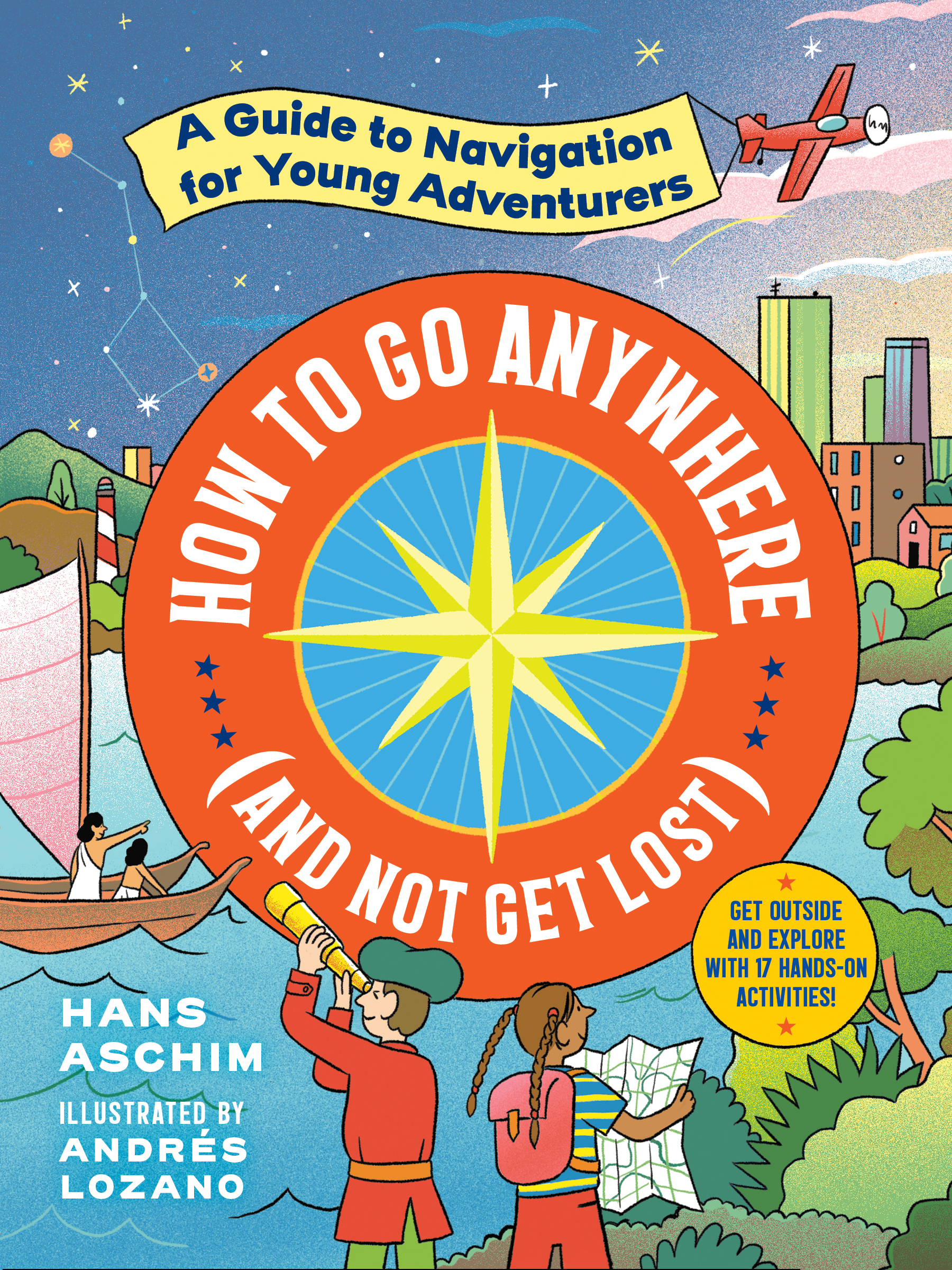
From journalist and adventurer extraordinaire Hans Aschim, here’s a lively and interactive book that gets kids unplugged and out of the house—and teaches them cool navigation techniques to use while hiking, camping, or just exploring the backyard or nearby park.
With lively full-color illustrations and full-color photos throughout, How to Go Anywhere (and Not Get Lost) combines fascinating history with fun hands-on activities that bring critical science, geography, and astronomy concepts to life. Readers will discover explorers and the tools they developed through the ages: from the ancient Polynesians who crafted stick charts to learn swell patterns in the water to navigate precise paths through the ocean; to Age of Discovery navigators who used compasses and maps to reach the New World; to the modern-day pilots who wield radar and GPS to soar across continents. Kids will also learn skills like taking their bearings with a compass; finding their way with dead reckoning; and locating their own latitude and longitude.
And best of all: 17 activities—making their own sextant, compass, stick chart, chip log, and more—will turn all young adventurers into young navigators.
This is a very thorough introduction to explorers and navigation for kids. It's filled with colorful illustrations and lots of history of how people around the world used the ocean, stars, sun, science, inventions and more to tell the time, find their location, measure their speed, figure out distances, etc. There are instructions for kids to replicate these on their own by making simple devices and using the knowledge themselves.
This is a really long, thorough book and I'm not sure how many kids would read all the way through without being really interested in the subject. It would make a good spine for a homeschool unit study, working math, science, history, etc. into a fun and educational topic.
I read a temporary digital ARC of this book for the purpose of review.
How to Go Anywhere (and Not Get Lost) by Hans Aschim
If you have youngsters around, or anyone who might be curious about getting around in this world, this is the book for you! Filled with historical knowledge gathered through the ages included right along with state of the art technology, this book can help anyone with the “where” part of questions. Best of all, home work is included! Projects and experiments conclude each section, to help practice and prove knowledge gained, right down to figuring out your very own longitude and latitude location. As a devoted grandma, I will be making sure each of our families have a copy of this book in their homes.
With this book, getting lost will become obsolete or intentional. No more of that accidental stuff.
A Sincere Thanks to Hans Aschim, Workman Publishing Company and NetGalley for an ARC to read and review.
This book is packed full of STEM-centered activities and information for middle grade readers. This book contains a very thorough introduction to explorers and navigation for kids. It is loaded with hands-on activities like making your own compass, mapping your house, and exploring your neighborhood. This is a great book for classroom and homeschool use.
I recieved a digital copy of this book from the publisher via Netgalley in exchange for an honest review.
Delightful book on navigation for kids, with lots of hands-on activities like making your own compass, mapping your house, and exploring your neighborhood. The fundamentals of navigation are explained in an accessible, understandable way, starting with an explanation of how humans are born to explore:
"Since the beginning, we've always moved around, whether it's for more space, more food, or just to see what's on the other side of the mountain. . . . Fresh air, some new company, and a kitchen restock are some of the reasons early navigators left the comforts of home for the great unknown - though they were tracking herds of woolly mammoths rather than picking up groceries down the block."
I learned a lot from this book and appreciate how it helped me notice directional and navigational indicators that I may have overlooked. I went outside afterward and looked for the different growth of trees indicating direction. I am looking forward to charting swells in water and estimating latitude.
This is a relatively long book (224 pages). Few kids may read it all the way through by themselves, especially as the activities seem pitched at different age levels. But it would be a great reference guide for parents, teachers, babysitters, Scout leaders, librarians, or anyone looking for easy to translate lesson plans and fun, educational activities for kids. Parents educating at home because of the pandemic could draw science, history, and math lessons from this book, although its expected publication date is not until March 2021. (Also, in the review copy I received, there appears to be a typo in the equation for speed.)
Many thanks to NetGalley for the ARC in exchange for an honest review.
“How to Go Anywhere (and Not Get Lost) by Hans Aschim is an essential guide for children on the science of navigation and wayfinding. Chock full of illustrations and activities, this hands-on book presents the information in an entertaining and easy-to-understand way. I loved how the activities directly related to the information, providing ways for the reader to explore and really understand what they are learning. The activities also use everyday objects that most people have handy around their home, like rope, rulers, and a fridge magnet. This means that anyone can try out the experiments without having to go out and buy or find the required objects.
I really enjoyed this book and learned a lot. I had no idea that there were animals that were innately able to utilize magnetite and the Earth’s magnetism to navigate. There were a ton of cool facts like this throughout the book. The Further Reading section at the end points to a number of websites and other books that the reader can find to further their knowledge and is a very useful addition.
My few concerns about the book is that while it is very interesting and educational, it can be a bit information-heavy at times, and might be hard for younger children to understand. There is a bit of a disconnect between the illustrations and the text. The illustrations are simple and colourful cartoons, and look to be aimed at younger children. The text is at times chock full of information and technical terms, and while written simply, would not be easily understood by young children and is more suited for older children or teenagers.
My other concern is that there is no disclaimer at the start of the book. Considering the subject matter, I felt like there should be something mentioning the importance of not going anywhere without telling an adult first and getting their permission or supervision, as well as how to contact authorities as necessary for when voyaging on government or owned lands.
Overall, this book is very well done and is a great resource for children who are interested in learning more about navigation and wayfinding, especially those who love exploring the great outdoors.
*I received a complimentary copy of this book on NetGalley and have provided an honest review.*
Thank you to @workmanpub and @hansaschim for sharing an advance copy of How to Go Anywhere (and Not Get Lost): A Guide to Navigation for Young Adventurers with the #kidlitexchange network. This book is set to be released on June 23, 2020. All opinions are my own.
This book is packed full of STEM-centered activities and information for middle grade readers. The book focuses on getting kids unplugged and teaching them cool navigation techniques to use when hiking, camping or just exploring their surroundings. Readers will learn about ancient techniques, like the stick charts used by ancient Polynesians, the discoveries made by navigators during the Age of Discovery, and modern day navigation techniques, like GPS. The book also includes 17 activities for readers. Activities include making your sextant, compass, chip log, and more.
I enjoy how Aschim combines science and history in this book. It was a lot of fun learning about how navigational techniques have developed and changed over the years. The content is well-researched and gives a thorough introduction to navigational techniques for young explorers. The chapters are well organized and full of interesting and useful facts. I also really like that each chapter includes a few activities for the reader to complete. The illustrations are both useful and fun. The concepts, which can often be complicated, are broken down in a way that makes them very easy to understand. Often the author uses a simile or metaphor to better help the reader understand the concept. The addition of the activities, gives the reader an opportunity to have a hands-on experience and develop an even deeper understanding of the concept being discussed. Overall, I really enjoyed this book and can't wait to share it with my fellow teachers and our students.
A guide for how to navigate using the sun, stars, landmarks, trees, compasses, GPS, and other tools. The book looks briefly at the history of various methods and tools used for navigation, and includes how-to guides for using things like the stars and landmarks to figure out your location and where you want to go.
We had to throw out our one book on compasses in our library when it started growing a healthy crop of mold so I went on the hunt for something to replace it. This was the closest thing I found. It definitely goes way beyond just how to use a compass, and strongly encourages readers to not be totally reliant on things that can run out of batteries or get messed up by magnets to find your direction. It does a good job of explaining a variety of ways to find your way without any high tech gadgets (or even low tech gadgets). The activities included throughout explain the concepts well, and you may end up with a kid all excited to try out orienteering or geocaching after reading this. It was fascinating to learn how some methods of navigating are in danger of dying out and how some are trying to make sure that does happen (like modern Polynesian wayfinders who set sail with only the wind, waves, sun, stars, and birds to help them make it from one island to another). Math teachers who want a way to prove to their students that math really does have very helpful applications in real life will love several of the activities in this that help you figure out your position using math. There's also quite a lot on latitude and longitude and explorers in here for those teaching those topics. And the book does a good job of highlighting historical figures from ALL over the world who contributed to navigation tech or calculations or exploration and not just Westerners.
Do you have a child who loves to explore? Is your child one who can't wait to try out a new path and see what is on the other side? Do they love to know what makes something work and why? Then this is the book you want to get. It presents a good overview of how people found their way around since the beginning of time. It suggests ways to find north when in the forest and invites you to go out and try them. Did you know that those ways change if you are in the southern hemisphere instead of the northern? Chapter one: early navigating in nature. Chapter two: navigating by the sun and the stars. Chapter three: distance and dead reckoning, ( Did you know that Lewis and Clark's calculations were only off by 40 miles out of 5000?), Chapter four: Finding Longitude- high tech hits the high seas, Chapter five: the almighty map and compass, Chapter six: The modern navigator: Radio Waves from Sea to space. In each chapter there are STEM activities that would be great for family adventures, scouting events or school field trips. This 224 page book is recommended for ages 9-11, grades 3-7 and it is due to come out on March 30, 2021. I suggest that you make yourself a note to find it when it comes out.
Want to learn how people found a way to plot a way to where they wanted to go? While It is written for kids this book will show many ways to learn how to navigate on land. It is interesting and fun as there are projects that can be done outside safely. If you have children, they will have fun doing them. It has history, astronomy and geographical information that gives one knowledge use for and fun. The history starts with the Polynesians And ends with the modern GPS that is used now. If for some reason you can’t use a Gypsy, you will have knowledge of different ways to find the direction you want to go. There are 20 activities in the book to do! It’s a great book!
Disclaimer: I received an arc of this book from the author/publisher from Netgalley. I wasn’t obligated to write a favorable review or any review at all. The opinions expressed are strictly my own.
"How to Go Anywhere (and Not Get Lost)" is a fantastic book. I was very interested about it when I saw the title and the description! I was fortunate to receive a copy from Workman Publishing Company through Netgalley. This book was beautifully researched and articulated for a young audience. I have an 8 year old who I think will enjoy it and I, as an adult, learned a lot! The writing brilliantly introduces a lot of content without being overbearing. I really appreciated this as a reader and parent. The illustrations are lovely and there are experiments throughout that make the principles come to life. Additionally, this makes a great reference guide to refer back to again and again! (Note: all my views are my own.)
It is difficult to convey how amazing this book is. I recommend it as a must-have addition to the family library. Young children will need help getting though this book, but it something that the whole family can do together. It weaves science, history, geography, linguistics together to give an incredible overview of navigation and wayfinding, whether you have modern technology at your disposal or not. The book contains detailed instructions for hands-on activities and making various instruments of navigation.
I received a digital ARC through Net Galley, but I will definitely be purchasing this book when it comes out. I cannot wait to make the instruments with my kids and explore more of the outdoors during our new covid reality.
As a science teacher and also a teacher of history I am always looking for workbooks or for supplements to add to my curriculum in the classroom. I like workbooks that allow the students to read about the topic in story form or in a way that interests them to learn how to do. This book teaches mapping, contouring, orienteering and many more topics that are needed to understand mapping and techniques to understand your place on Earth and the navigational skills for land, water, and space. Activities for hands on learning are easily listed in step by step order in language that students will not feel intimidated by. Filled with color and good relatable history on mapping in many forms. Would use this in my classroom without a doubt.
Neat book, full of math and science. It meshes well with earth science curriculum. I appreciated how the book started with the earliest forms of navigation, then explained the gradual advancements made to tools of the trade. The book is peppered with easy to do activities, some taking place at home, some out in the world at large. If you're interested in navigation or wayfinding, this is a book you'd enjoy. For the casual reader, I found it hard to focus on all the details. There are great little nuggets that caught my attention here and there, but I found myself skimming parts.
Thanks Netgalley for the ARC! All opinions are my own, unbiased.
I like the mix of history, science, and geography. There are some interesting stories/facts and lots of good info as well as a variety of activities to make concepts clearer. I think the math in the book will make some kids' eyes glaze over, but if you skim over those parts for that type of student, I think this is a decent intro to navigation topics. Also - for young earth creationists, be aware that there is the typical 700,000 years ago type of stuff in a few places. ;-) Overall, this is a decent homeschool book. It's not earth shatteringly fantastic writing or anything, but it's solid, nonetheless.
This is a great book for kids! It is full of tons of activities that teach the reader about using their environment and simple tools to navigate, tell time, calculate speed and distance, and more. I tried a few of the activities out with my 10-year-old and I can't wait to share more with my girl scouts. For someone who has a decent sense of direction, but little knowledge of true orienteering, I found this to be a great resource! Thanks to #netgalley and Workman Publishing for the ARC e-book sneak peek! #HowtoGoAnywhereandNotGetLost
How to Go Anywhere (and Not Get Lost) is a great informational book with colorful pictures and fun activities for kids to get some hands-on learning. The book talks about the history of humans moving through the world and how navigation evolved with them. My 9 yr old enjoyed the book but skimmed to parts that he thought were really interesting as the book is pretty long.
I was provided with an electronic ARC through NetGalley and the publisher in exchange for an honest review. All opinions are my own.
I learned soooo much from this book, especially about water current navigation and ways of telling direction before the compass was invented. Plus, who knew how hard it was to create a clock which worked on a ship? Or what dead reckoning meant? The activities seem really cool too, although impossible to do in the city, so we have to remember to bring the book on vacation.
This book has lots of information on the history of navigation from using the stars to figuring out longitude and latitude to radar and gps. It was a wonderful history of all things adventuring. I especially appreciated all the activities in the book and I think kids will enjoy doing their own navigating.
If you get away from the fact you can’t go anywhere, this is a nice book for families. The book has nice exercises and so much information. The illustrations were so so,
Thanks to NetGalley for the arc in exchange for an honest review.
How To Go Anywhere (And Not Get Lost) By Hans Aschim is an awesome book about exploring for children. This is a interactive book that gets kids unplugged and out of the house—and teaches them cool navigation techniques to use while hiking, camping, or just exploring the backyard or nearby park. I love this book and my children do too! it is written in a easy to read fun way. My kids can pick up the book begin reading and plan their next outdoor adventure all while learning important life skills. The book starts by telling some of the history of early navigators. There are sections titled the sun and the stars, high-tech hits and high seas, the almighty map and compass, radio waves from Sea to space. Each section gives loads of information and even includes different activity's for the child to do. This book will teach your child how to navigate. This book will show your child how to make a map, how to figure out where North, South, East and West are. How trees can give you clues in finding your way! You can make your own star clock and much more! I highly recommend this book and think it would make a great addition on any child's book shelf. Every school library should have a copy as well.
This title offers elementary school aged readers an historical perspective on navigation along with fun navigation activities. The book starts with a timeline; this begins 70,000 years ago and moves to modern technology and the electric car. We go on from there with chapters on topics including early navigators, the sun and stars, and more ending with a chapter on space.
This book has appealing, colorful illustrations that add to its content. The activities should engage the audience. For example, the first asks children to draw a detailed map of a place that they know. The author then asks kids to visit somewhere such as a friend's house and to then make another map. The point is that it is easier to be detailed about places that are well known to us.
After learning the cardinal directions, children learn how to read the trees and how to practicing this skill. This is just a brief introduction to the riches of this title.
If you would like to get your child out of the house and interested in navigation, history, science and some fun that does not involve screens, consider this title.
Many thanks to NetGalley and the publisher for this title in exchange for an honest review.
This concept intrigued me, so I was excited to receive a compimentary copy of the book through NetGalley. First impressions are important, so it was disappointing to open the book and immediately see a worldview presented as fact when it is clearly unscientific. If the claim of "millions of years ago" is not supported by science, it begs the question of what other claims in the book are unreliable. All in all, I enjoyed the book and would recommend it to my students with the disclaimer. The book is broken into "bite-sized" pieces, and continues at a reasonable pace for grades 3-6. There are fun activities to reinforce the concepts. I imagine it as especially suitable for homeschooling families.
I thoroughly enjoyed this book. My daughters and I love going on hikes and adventuring, so this was the perfect read for us! We tried out some of the neat ideas and they both thought it was the coolest thing. The illustrations and layout is wonderful! All the bright colors are great and are very appealing, especially for children. The way the author chose to weave history along in with the adventure tips was a very fun and original way to do it. It’s definitely a book we’ll look back on anytime we’re wanting to explore outdoors and try a few new fun ways to get around and see “the world”! Thanks so much to NetGalley for this free copy for my children and I to enjoy!
Early navigation and exploration and animals the original navigators. Other things - clues in trees, dunes, Lewis and Clark. It does have some activities that relate to topics. A good introduction to kids about navigating.