Reveals the little known history of one of history’s most famous maps – and its maker
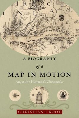
Tucked away in a near-forgotten collection, Virginia and Maryland as it is Planted and Inhabited is one of the most extraordinary maps of colonial British America. Created by a colonial merchant, planter, and diplomat named Augustine Herrman, the map pictures the Mid-Atlantic in breathtaking detail, capturing its waterways, coastlines, and communities. Herrman spent three decades travelling between Dutch New Amsterdam and the English Chesapeake before eventually settling in Maryland and making this map. Although the map has been reproduced widely, the history of how it became one of the most famous images of the Chesapeake has never been told.
A Biography of a Map in Motion uncovers the intertwined stories of the map and its maker, offering new insights into the creation of empire in North America. The book follows the map from the waterways of the Chesapeake to the workshops of London, where it was turned into a print and sold. Transported into coffee houses, private rooms, and government offices, Virginia and Maryland became an apparatus of empire that allowed English elites to imaginatively possess and accurately manage their Atlantic colonies.
Investigating this map offers the rare opportunity to recapture the complementary and occasionally conflicting forces that created the British Empire. From the colonial and the metropolitan to the economic and the political to the local and the Atlantic, this is a fascinating exploration of the many meanings of a map, and how what some saw as establishing a sense of local place could translate to forging an empire.
The name Augustine Herrman does not appear often in the history of the Mid-Atlantic Region, yet in the seventh century his influence was a major facture in defining the boundaries and configuration of Virginia, Maryland, Delaware, and Pennsylvania. Christian Koot tells the story of this forgotten Renaissance man. Herrman was trained in the Czeck Republic as a surveyor. He came to North America in 1633 and quickly became a respected trader and planter, in the Chesapeake Bay Region; He was among the first successful businessmen in the tobacco-trade; he became wealthy from the export of Tobacco from the Mid-Atlantic Region to Dutch and English ports. In addition to his business talents and his strong personality, he became an important member of the Dutch and English community, he advised the leaders of the Region and the representatives of the European powers. As an example, he had a disagreement with Lord Baltimore over his charter. Herrman’s argument was that the charter authority only applied to lands that had not been previously settled, and that the settlement at Lewes, Delaware, gave the Dutch prior rights to the whole Delaware River watershed. Lord Baltimore rejected the argument completely, but later the English successors to the Dutch title, the Duke of York and William Penn, agreed with Herrman's interpretation and they were successful in making the case, ultimately leading to the separate existence of the State of Delaware. This is just one example of the power and influence Augustine Herrman possessed in the Region. In further dealings with Lord Baltimore, he offered to produce a map of the Region that would clarify boundaries and would make the Chesapeake Bay and its tributaries less difficult to navigate in return for a grant of land of his choosing. The offer was accepted, and the grant was made in September 1660; Herrman’s map did its job of expanding the knowledge of the entire Chesapeake covering the States of Virginia and Maryland. As compensation for his services Lord Baltimore granted him "Lands for Inhabitation to his Posterity and the Privilege of the Manor." Herrman selected his first grant of 4000 acres of land and named it "Bohemia Manor" after his birthplace. It included much of the land east of the Elk River and north of the Bohemia River. The manor house was built on the north shore of the Bohemia River and Herrman moved his family to Maryland in 1661. The story of this map illustrated by Koot is quite interesting. The map was unique because the detail provided was the best of the age. The major rivers of the Chesapeake are described, towns, plantations and waterways and importantly boundaries were set. Inlets and streams were listed, including navigation aids of the dangerous shallows and sandbars. The map was invaluable to European merchants because it provided a very valuable navigational aid for traveling the Bay and its tributaries. While Hermann’s feat is a masterpiece, Koot educates the reader about the elaborate process of engraving and printing of the map. This was the 1670’s and everything was done by the hand of a craftsman. KOOT’s research is impeccable as he describes the elaborate processes that took part in the creation of this map named the Map of Virginia and Maryland. The stories of the various individuals and companies who worked to create the map are quite interesting. This map set the standard for future maps, they all copied from Hermann style and content. The book goes on to describe the English bureaucracy and the establishment of the “The Board of Trade” This organization was formed to track, tax and account for cargo ships leaving and returning to British ports. This story line was of great interest to this reader. Over the years, I have made many trips to Bay area towns, I heard of stories of ships coming into small riverside ports for trade. So, I pictured a Dutch or English traders navigating the shallow waters of rivers that go inland off the Bay like the Miles or Choptank rivers, these ships had to avoid the rocks and shoals while looking to dock in a trading center. The period would be about the late sixteenth or early seventh century and the community would have had little or no prior knowledge of the ship’s arrival. So, by word of mouth the message would go out into the farmland that a trading ship was docked. Farmers would bring their highly valued farm products like tobacco and other desired goods to the ship to negotiate and sell their merchandise, usually through the barter for the European goods desired by the local population. There were no checks and no credit, just either barter or cash were exchanged. The ship would retrace its steps back down the Bay to the sea and home to Europe. The sales were only known to those who participated, and no tax was leveled or collected. A chapter was included describing the formation of The Board of Trade based in London to modernize the antiquated system of trade and gain a revenue source by taxing the shippers; it was a political act! The government wanted to understand and harness their mercantile interests to better manage their growing empire and Hermanns map was a valuable tool for even The Board of Trade. Koot provided an excellent narrative combined with his detailed research. In another interesting chapter, Koot takes the reader to the upper reaches of the Bay. The area that Herrman settled after receiving his grant from Lord Baltimore. This is another excellent topic that explores the area transversed by travelers and merchants going from the Delaware Bay to the Chesapeake Bay. This area was just a deer trail than an Indian trail that became a short cut that eventually became a canal. Koot described the impact the grant to Herrman had on this area, he spurred development of the entire region. Herrman’s wealth and influence allowed him to secure another estate from the governor of New York for his son in what is today the State of Delaware. Koot’s scholarly work is surprising not just for its depth and quality but for bringing to light the early development of this Region and a biographical sketch of Augustine Herrman, a man who while not well known had a major impact on the commercial development of the Mid-Atlantic Region. This book is truly a scholarly work; the depth of research is amazing along with an all-encompassing bibliography.