
Russ Eanes's Blog, page 2
May 27, 2022
Where to stay on the Way of St. Francis
The Way of St. Francis offers a range of lodging options and during our pilgrimage to Assisi in April of this year (2022) we took the opportunity to experience that entire range.
 Rifugio Asqua, in the Casentino National Forest, about 5k before Camaldoli.
We booked ahead always, typically a day ahead, but in a couple of instances we booked well in advance, such as La Foresta at La Verna and Hotel Alinari in Florence, where we stayed our first night. In 2019 on our walk from Rieti to Assisi, we booked the entire 14 days in advance on booking.com, but found then that we no longer had the flexibility to change our walking plans, which we had wanted to do immediately. This time around we appreciated flexibility, since the challenges of walking this route (both the elevation gains and the remoteness) meant we needed that it.
We liked the range of options that we chose, from hotels to B&Bs to Refugio’s and monasteries. We booked a few through Booking.com, but more often used email or phone to make our reservations. Your host can even call ahead for you for the next night, too. Of all the places we stayed there was only one that we would not recommend, the Istituto Maestre Pie Filippini and that was because we stayed two nights and it was very inconvenient having the nuns let us in; they also spoke no English.
Here is a list of all the places that we stayed, (most recently in 2022 and also in 2019) including costs and contact information. This list is Florence to Assisi, then Rieti to Assisi.
Our average cost per person was about $50 and that often included breakfast and sometimes supper. Some of the remote locations require having both, since there is nowhere else to stay. Some will even pack a lunch for you, if there is nowhere to stop for food during that day’s stage.
We used four resources to book our lodging, and that included the two guidebooks that we had access to. Two lists exist online and I suggest downloading both before you go; see links below to download.
Sandy Brown created this spreadsheet several years ago. Some of the details may be dated, including costs and availability.The Way of St. Francis Association Tuscany has this list (in Italian!) which is very useful, including email addresses and phone numbers. All information is current (Spring 2022).We preferred to use accommodations that were from these resources, whether we booked them by email, phone or on booking.com. This was because those places offered the best opportunity to connect with the pilgrim community, including hosts.
One thing to note is that along the Way of St. Francis, many of the lodging options are not for pilgrims only and you may be competing with day hikers and tourists. At least three times we found that we had to alter our plans because lodging was full and not with pilgrims. Also be aware that during Italian holidays (such as Easter) these places will be especially full.
Russ Eanes is a writer, walker and cyclist from Harrisonburg, Va. and the author of The Walk of a Lifetime: 500 Miles on The Camino de Santiago.


How the Way of St. Francis compares to the Camino Frances in Spain
Many people who are interested in walking the Way of St. Francis (Via di Francesco) in Italy have already walked a pilgrimage to Santiago de Compostela, very likely the Camino Frances (French Way) in Spain. (And the names of these two routes are similar enough to create confusion for anyone not familiar enough with either.)
 One of many steep ascents along the Way of St. Francis, between Valfabrica and Assisi.
Having walked both myself, here are five ways in which the two are different.
On the Via di Francesco, they speak Italian. This point may seem obvious, but there’s much more to it. On the Camino Frances, English, not Spanish is likely to be the common language, even if people come from around the world. While fewer people in small towns or villages in Spain speak English, most of the hospitaleros do, as do many pilgrims. An American can get by with minimal Spanish. But in Italy, there are even fewer people in the small/rural towns who speak English and while some pilgrims do, it is vital to know some Italian, especially basic phrases. On our walk, we met no Americans and only one Brit. Most of the pilgrims were from Germany, Austria and Switzerland.There is a whole lot more climbing. A WHOLE LOT more. For those who have climbed the Pyrenees coming out of St. Jean Pied de Port (the starting point of the Camino Frances) the Way of St. Francis is like climbing that stage every day, for several days on end. This is especially true for the 6 days’ walk into La Verna. Elevation gains need to be taken into serious account and it’s not just the gain; the descents are often equally difficult, especially if the slope is rocky or muddy. Walkers can expect to make much slower progress. Poles are even more strongly recommended, especially for older walkers.There are fewer pilgrims-only accommodations along the way, with a mixture of hotels/hostels/pensions and guest apartments the norm. Call or email ahead, too, at least one night before. And unless you are in one of those rare pilgrims-only accommodations, expect to compete with other tourists and day hikers. On our 16-day journey from Florence to Assisi we found that we had to find alternative accommodations at least three times because there were no rooms available in our intended destinations and it wasn’t because there were a lot of pilgrims. And learn to ask (in Italian!) if they speak English, if you do call ahead. If they don’t, make sure you can ask for a room in Italian! (You can also ask a host to call ahead for you for the next night.)You will have to pack food and/or water for the day, for several of these stages. This is rarely the case in Spain, where a mixture of bars, restaurants and grocers are typically open in villages every few kilometers. Bars will give pilgrims water for free and many towns have fountains with potable water. On our sixteen day walk from Florence to Assisi, we found that we needed to pack food about half the time and extra water about a fourth of the time. This adds extra weight (just when you are about to climb, too!) and requires more planning.Much more of this walk is quite remote. The route through the Casentino National Forest, which comprises three of the first six stages, is largely dirt trails and dirt roads and few houses or villages, more reminiscent of the Appalachian Trail than the Camino Frances. Even in the remote a areas, however, we always had a good cellular signal. We were glad to have Italian SIM cards in our phones. In many places the trail crosses rivers and streams and on more than one occasion we had to ford them in our sandals. A pilgrim blessing and sendoff from Eremo San Pietro in Vignetto.
To date we have walked about 3/4 of the route, first from Rieti to Assisi (in 2019) and then from Florence to Assisi, this April (2022). We loved every minute of it, even if it was challenging. The Italian hilltop towns are beautiful, the food delicious and the scenery charming and historic. I plan on finishing the last stretch–Rieti to Rome–in September of 2022, about 110 kilometers.
 The hilltop town of Cantalice, near Rieti.
 Mountain scenery outside of Gubbio.
We recommend that experienced walkers look carefully at the elevations along the route before estimating distances you might walk in a day; consider shorter stages than the guidebooks recommend. A list of distances, elevations and percentage climbing for each stage is attached here. This list is according to Sandy Brown’s guidebook, Trekking the Way of St. Francis.
 Fording a stream on the way to La Verna.
The most wonderful thing about this walk is how relatively uncrowded it is! While we encountered the occasional pilgrim, the small towns and villages were authentic Italy. Some places, such as Florence (a starting point) or Gubbio, La Verna or Assisi do have lots of tourists and we encourage booking lodging in advance for those stages.
 La Foresta, monastery at La Verna.
Many pilgrims also choose to start the walk in either La Verna, Assisi or Rieti. There is no stated start/end point such as on the Camino, which makes it desirable for a one or two-week trek. Transportation to and between towns is also available on inexpensive buses, which also means that you can skip a stage one day if you are worn out, injured or just needing a rest. We did that at least once, when the weather was bad and the route ahead was expected to be muddy.
 Interior of San Giovanni Battista in Loreto. The current church was reconstructed in 1233 atop an earlier foundation; the crypt, which is open, is even older.
The Way of St. Francis is an adventure and a wonderful opportunity to experience the ancient, historic culture of Italy, one footstep at a time. Explore it!
Russ Eanes is a writer, walker and cyclist from Harrisonburg, Va. and the author of The Walk of a Lifetime: 500 Miles on The Camino de Santiago.
April 29, 2022
Into Assisi
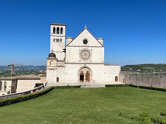
After 16 days, 150 miles (250k) and more elevation gain that I kept track of, we reached Assisi on Wednesday this week. It was the great end to our pilgrimage.
 Roman Theater in Gubbio.
We had entered Assisi over two years ago on our first pilgrimage here and it was a wonderful feeling. This time was no exception. In 2019, we entered through the South Gate, this time from the North.
 Entrance to Assisi!
When I left off this journey, we were on our way into Pieve San Stefano, after leaving Della Verna. The worst of our climbing was over, but ahead lay several days of potential rain.
 Jane looking back towards the Apennines.
We decided to take it one day at a time, rather than fret about potential rain. This was a good decision, because we had only one serious day of rain in the next 8 days.
 A 12th century church along the way.
But rain and the potential for rain, did play a factor in our decision to take a bus from Sansepulcro to Citta di Castello. We also needed some serious rest. It was a good decision.
 A good breakfast!
We also took a day to rest in Gubbio, a delightfully charming city built on a mountainside, where we got to take a cable car (cage, really) up to a church on the top of the mountain. Spectacular ride and spectacular view.
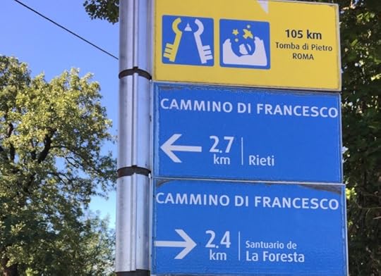
 Signs along the way
Our last three days after Gubbio were the best—lots of sunshine and gorgeous, green countryside. The highlight of this section of the walk was a stay in San Pietro di Vigneto, an old hermitage/monastery that now operates as a donation-only pilgrim hostel. The night we were there, we were the only pilgrims. But we had a great conversation with the volunteers that run it, Primo and Nadia, both from Italy.
 Farewell at San Pietro, from Nadia and Primo.
On the 27th of April we walked into Assisi, after a night in Valfabrica. The last day was sunny and warm and we took our time. We are going to miss being pilgrims. We love the simplicity of the trail, the simplicity of having nothing more to worry about than walking and nothing more to care for than what fits into our packs.
 Last Day!
Our last stop before we head home is Florence, home to some of Italy’s greatest art and birthplace of the Renaissance.
Talk about Assisi.
April 18, 2022
Florence to Assisi—one week in
Tuesday April 12 we left Florence, on our way to Assisi, a two week pilgrimage along the Via di Francesco, or Way of St. Francis. We walked first through city streets, then suburbs, then to the open countryside, to Pontassieve, which is about 20k upstream from Florence on the Arno River.
It’s been seven days now since we began our pilgrimage from Florence, Italy, to Assisi. I would call it a week of “ups and downs” quite literally, since we find ourselves mostly climbing and descending.
 A view down the mountain valleys
That day, and the next, we passed kilometer after kilometer of olive groves and vineyards, slowly climbing our way into the Apennines, which form the centrail spine of the Italian peninsula. We enjoyed meeting other pilgrims, most of whom were from Germany.
 Olive groves
We also met some wonderful people who love to host pilgrims and loved to hear their stories and passions for this pilgrimage route. One family in particular has resettled on a family farmstead and restored a 10th century church next to their house. The evening we spent with them was probably the best of the week.
 1,000 year old church at Rifugio Jacobo
 Luca and Elena and their children, our hosts at Rifugio Jacobo.
On our third day we entered the Casentino National Forest and have been in or through parts of it for the past four days.
 Pine trees in the Casentino National Forest
 Monastery at Camaldoli
The forest is very remote, but we also pass through some small villages and quite a few monasteries, some of a which are 1,000 years old. Yesterday, Easter Sunday, we arrived at a very famous Franciscan monastery, Della Verna, the place that St. Francis is purported to have received the wounds of Christ, or the Stigmata. This is a very mystical place, a very refreshing place to visit.
 Della Verna
We left there this morning and arrived mid-afternoon in Pieve San Stefano, in the upper Tiber Valley. It was the first time in four days that we entered a substantial town or village.
 Meeting a mountain biker on the way into Pieve San Stefano
The weather was quite warm the first several days and we hiked in shorts and a t-shirt. Since Friday, the weather has cooled and it’s been very windy, particularly in the higher mountain passes that we’ve been through.
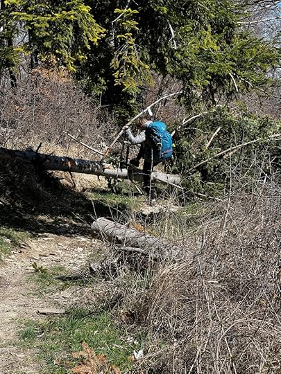
 Wading a mountain stream
The Apennines remind me very much of the Blue Ridge mountains at home, similar in altitudes. I was surprised by the large numbers of trees that have fallen over or been snapped in half by windstorms.
Altogether we have walked 115 kilometers, but even more challenging, we have climbed over 5200 meters in elevation. We are not done yet—more climbing to come as we leave Tuscany tomorrow wand head into Umbria.
In eight days we hope to reach Assisi. We feel fortunate not to have had any injuries or serious problems so far. We love this adventure!
April 11, 2022
Pilgrimage Prologue
 Duomo in Florence
We finally to got Florence, our first overseas trip in over two years. Our first flight was Washington Dulles to Munich and it was full. The airport felt very much like it used to—quite packed actually. Other than having to wear a mask continually for over 18 hours, it felt quite normal. We got to enjoy the lounge chairs in the Munich airport during our 4 hour layover.
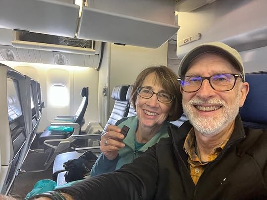
 Jane relaxes and even dozes off (at an airport!)
The one-hour flight on Air Dolomites (a firsts for me) was dramatic and had me glued to my window. I had the entire last two rows to myself, so I moved from side-to-side on the plane. First the Alps, then the Dolomites, then the Adriatic, then the Apennines, then finally to Florence.
 The Tyrol—Italian Alps.
Our transport into the center city, where we are staying one night, was a tramway. We found our hotel without too much trouble and, forcing to keep ourselves awake, headed out to get a quick espresso, a small bite to eat, sim cards for our phones and stamps on our pilgrim credentials, or credentialed. Those will help us get discounts or access that regular tourists don’t have.
First full-on view of the famous Duomo The Duomo is everywhere!
We know that we‘ll be back at the end of the month for a few days to appreciate Florence, so for now we are getting ready to head out in the morning on the first stage of our pilgrimage, a walk that is close to 25 miles. We can’t wait to see what we will experience!
 Basilica of San Croce, where we got our first stamps.
April 9, 2022
Keep on Trekkin’
After a two-year wait, my wife and I are finally getting the chance to return to Italy and resume our walk on the Way of St. Francis, a newer pilgrim trail that goes about 350 miles from Florence to Rome, through Assisi, the home of St. Francis.
 The Basilica of St. Francis in Assisi
In 2018 I walked the Camino Frances, the most popular of the Spanish Camino, 500 miles. It was life-changing and my wife joined me for the final week and we decided right there and then that this was something we wanted to do every year. We picked the Way of St. Francis as our next pilgrimage.
In September of 2019 we walked a section it, South to North, from Rieti to Assisi, about 90 miles. We loved it. The Way of St. Francis is more challenging than the Camino de Santiago, with much more elevation gain. There are fewer places to stay, and fewer pilgrims. But the Italian hilltop towns have a distinctive charm and drip with history.
 The hilltop town of Poggio Bustone
Next week we will begin in Florence, walking this time North to South, ending again in Assisi. The distance this time is more like 175 miles and we will be tackling some significant elevation gains in the Apennines. That challenge is part of the adventure. We hope to return in the fall, to complete the remaining section that we have not done, Rieti to Rome. I hope that a book comes out of this adventure, since many who walk the Camino de Santiago would want to give it a try.
 Two German walkers we met in 2019, aged 76 and 80! And carrying packs weighing over 10 kilos (22 pounds.)
It was hard, waiting two years, to return to this trail. Like many other pilgrims, we missed these sacred routes and eagerly hoped for travel to reopen safely. We started training in late February, getting used to gradually longer walks with our packs. We will carry around 13-15 pounds each, maybe a bit more with extra food or water. 10% of body weight is recommended and for us both that is about right.
 Five mile climb to Skyline Drive
We always hike with poles when we can. Besides helping us keep upright on uneven or slippery terrain, they can relieve around 30% of the pressure on joints.
 Final training climb!
Last weekend we did a final, big challenge, a 10 mile walk up the Blue Ridge, elevations and terrain similar to what we will have to tackle in Italy. Now we are ready to head to the Apennines!
Russ Eanes is a writer, walker and cyclist from Harrisonburg, Va. and the author of The Walk of a Lifetime: 500 Miles on The Camino de Santiago.
Email Address:
Subscribe
December 8, 2020
Putting it all together: “A Ride of Passage” takes shape
Writing a book, for me at least, is like putting together a puzzle: there are lots of pieces, you may have a sense of what the final thing looks like, but you don’t know yet how they all fit together.
That was certainly the case when I wrote my first book, The Walk of a Lifetime: 500 Miles on The Camino de Santiago. I had lots of stories, lessons, and anecdotes, but no clear idea of how each fit into the narrative that was going to become a book.
When I do a puzzle I always begin with sorting pieces. I match colors, recognizable images and look for edges; they constitute the frame, the outer boundary. They also produce a skeleton, a framework—albeit, from the outside—for the whole.
Assembling a story, whether it be a work of fiction (a novel, say) or a memoir is the same way. It’s necessary to create some kind of order or framework around which to write. I understand that many writers are free-spirited and creative (so am I), but that does not mean that we don’t have some order in our creativity. Even a painter stretches a canvas for a painting, and that determines its size.
My last book started with that large collection of stories, thoughts, reflections and experiences that I had while I walked across Spain for six weeks. I added to that my own research and reading on culture and history. I’m doing the same thing for my next book.
A Ride of Passage (no subtitle yet) is about a 335-mile bike ride from Pittsburgh to Washington D.C. that follows an abandoned railroad and canal trail along several major rivers. Its framework is the ride itself: what I saw, who I met, what I experienced. As I pedaled, I kept a journal via blog posts; one for each of seven days’ experiences. That’s the rough outline.
That outline has been built into a table of contents. Each of the seven days has been roughly figured as two chapters, with each chapter to be about 2-3,000 words. Each chapter has my reflections on this unique journey, one that is powered solely by my legs. My reading and past knowledge of the area is adding more history, geography and culture to the mix. I hope that by the time I am done to have a book that will give a reader some inspiration to ride all or part of this trail.
I’m looking to complete the first draft by the end of the year. After that I will let the manuscript sit and ferment for about three weeks, during which time I will create maps and choose photos. When the fermentation is over, I’ll revise it, then send it out to “Beta Readers,” who will give me feedback for a final draft. Beta Readers are people who are interested in reading an early version of my book and in exchange for reading and feedback, will get a free copy of my book when it comes out.
After hearing from Beta Readers, I’ll try and incorporate their input and then hire an editor who will work-over the whole manuscript. It’s an intense process and no guarantee that there won’t be major changes. My experience is that a good editor will ask a whole lot of questions, some of which will create major revisions to the manuscript, as well as making any good writing better.
If everything is aligned, I’ll have a final draft by early March, but before then I should have a book cover (and final title) which I can use in making announcements. I’m aiming for a May 1 release date. After that, depending on the pandemic situation, I will start to do some live promotional events, which might include cycling back to Pittsburgh from D.C., this time with a group.

October 2, 2020
Pittsburgh to Washington wrap-up #3: recommendations
Several People have asked me about specific recommendations along the GAP and C&O towpath. I traveled at an unusual time of year, Labor Day weekend during a pandemic. This means that a lot of historical sites which I normally would recommend visiting, as well as restaurants, were either closed or had curtailed hours. Yes, other than Ohiopyle State Park, hours were curtailed Labor Day weekend! In Cumberland, on Labor Day, I found only one restaurant open.
When I publish my book next year, I’ll include a more complete list, but for now here are few places and sights that I can recommend, including some that a person might overlook, beginning with lodging and food recommendations.
Lodging: I chose not to camp and can recommend several of the places I stayed. The Comfort Inn in Connellsville is clean and convenient, right along the trail and right next to the river. Morguen Toole in Meyersdale was clean and inexpensive. I stayed in a hostel room, but I was by myself. The Town Hill B&B was superb; the biggest breakfast ever and they will shuttle you up the mountain to their place for a reasonable charge. (There are few other options in Little Orleans.) I can recommend two other hotels, the Ramada in Cumberland (about four blocks from Canal Place) and the Red Roof Inn in Williamsport. The last one looks a bit seedy from the curb, but the rooms were clean and it was cheap. It is over a half mile from the towpath, however. I stayed at the Harpers’ Ferry Guest House. Loved the place and would recommend it heartily, though it’s a climb to get there!
[image error]View of the Yough River from the deck at the Comfort Inn
[image error]Harpers Ferry Guest House
Food: In Pittsburgh a perennial favorite is Buca di Beppo, in Station Square. Italian food, served family-style. (Maybe not the best during Covid-19, but worth it if you are with a group.) In West Newton there’s the Trailside, my favorite for afternoon ice cream. Ohiopyle is full of places to eat, perhaps the most famous being the Falls Market, but I just discovered the Bittersweet At The Falls cafe, which serves cappuccinos, a great midday pickup. Cumberland was pretty much closed-down when I was there (Labor Day) but I discovered Uncle Jack’s Pizzeria and they had lots of outdoor seating and good food. From Cumberland to Hancock, the pickings are slim, but the School Kitchen in Oldltown is worth a short diversion, if even just to get some cold water. Shepherdstown is also worth a stop; I can recommend the Lost Dog Cafe, but the town is chock-full of places to eat and drink. Same thing is true of Harpers Ferry, and for those of you who are vegan or vegetarian (like me) and are willing to climb up to Bolivar Heights, there’s the Kelley Farm Kitchen. Nearby is The Barn, an excellent place to stop for al cold brew. My last day I stopped for lunch at White’s Ferry Grill–they have excellent sandwiches.
[image error]Pasta at Boca di Beppo.
[image error]Bittersweet at the Falls, Ohiopyle
Washington Heights. This is a place not to be missed, in Pittsburgh. I stayed in an Airbnb just at the top of the McArdle Roadway. There is a wonderful walkway along the edge of Grandview Ave. and the view is truly grand. At one end is the Monongahela Incline and about four blocks the other way is the Duquese Incline. You can take your bicycle up or down the incline. At the base of the Monongahela Incline is Station Square, where you find Boca di Beppo. You can also catch the “T” which is the light rail that runs through downtown and the South Hills. Bicycles are allowed on board.
[image error]Scenic overlook on Mount Washington
Montour Trail. If you have an extra day or two in the city, this is a pleasant rail/trail that extends 46 miles from near Coraopolis on the Ohio River, west of Pittsburgh, to Clairton, south of Pittsburgh, on the Monongahela River, where it connects to the GAP. The trail itself has several connectors, including one to the Airport and another into Bethel Park, which you can get to on the “T.” It also intersects the Panhandle Trail, which goes to Weirton WV, on the Ohio River.
[image error]A bridge on the Montour
The GAP is paved for the first 15 miles out of Pittsburgh and there are several historical markers and places of interest that are worth stopping to check out, such as Homestead, where there was an epic showdown in 1882 with striking steelworkers. At about milepost 136 you pass below Kennywood Amusement Park, where you can pause watch the Phantom’s Revenge rollercoaster as it plunges and arcs above you.
[image error]The Phantoms Revenge at Kennywood, taken from the GAP
There are quite a few visitor’s centers along the GAP. I enjoyed stopping at the one in Boston, which also has an original Pittsburgh & Lake Erie boxcar. Another one is in Meyersdale, which is actually a small, free museum.
[image error]Visitors center in Boston
[image error]Museum and visitor’s center in Meyersdale
The Youghiogheny Gorge is the pearl of the entire GAP: 25 miles of remote and beautiful scenery as the river cuts through the first two of the Allegheny Mountains–Chestnut Ridge and Laurel Ridge. At the center of it is Ohiopyle Falls, a “must” diversion along the way. DO NOT be in a hurry when you pass through town. It has lots of eateries, but can be very crowded on a Summer/Fall weekend.
[image error]Ohiopyle Falls
The GAP has four tunnels, the most spectacular of which is the Big Savage, just east of the Eastern Continental Divide. At 3,294 feet it is the longest on the entire route between Pittsburgh and Washington D.C. On the eastern end of the tunnel is an overlook of the valley down to Cumberland. It has benches to take a rest, and I fully advise a photo op. Make sure you remove sunglasses before you enter the tunnel and have a front and rear light. If the lights are off, proceed on foot, but not without a light. Riding through the tunnel can be a bit unnverving (it is for me) but the secret to staying on the path is to keep your focus on the proverbial light at the other end.
[image error]Eastern entrance to Big Savage
[image error]Overlook east of Big Savage. This is my youngest son is 2010. He pedaled 75 miles from Cumberland to Ohiopyle at age 12!
The Paw Paw Tunnel (milepost 155 on the C&O) is also unique. Almost as long as the Big Savage, this canal tunnel cuts through 3,118 feet of rock. The surface is uneven and you should dismount and go on foot. Like Big Savage, have a light on the front and back of your bike.
[image error]Deep inside the Paw Paw tunnel, lined with 6 million bricks. Looking West.
I can also recommend skipping parts of the C&O towpath between Little Orleans and Big Pool (milepost 113) and riding the Western Maryland Rail Trail (WMRT), a distance of 26 miles. The WMRT is paved and offers a relief from the dirt/gravel towpath. It parallels the C&O, so you really don’t miss anything and you can go faster.
[image error]Western Terminus of the WMRT in Little Orleans
A new place for me was Shepherdstown, WV, on the south side of the Potomac and about a 10 minute diversion from the towpath. This is an artsy college town with lots of good eateries and, if you have the time, shopping. Well worth a stop. This is also the point in the trail where the surface is paved with limestone, going east. Unfortunately this superb surface ends at milepost 30…
[image error]Shepherdstown
[image error]The turnoff to Shepherdstown, also the place where the towpath is paved with crushed limestone.
Harpers Ferry is my favorite place along the C&O. Full of history, the town has been turned into a museum. I can recommend a day here. There are lots of great places to stay and eat while you see the historical sights and hike the Maryland Heights, where you get a spectacular view of the town.
[image error]Harpers Ferry from atop Maryland Heights. The bridge on the lower left is the footbridge for cyclists.
September 23, 2020
Pittsburgh to Washington Wrap-up #2: Gear
A few people who are contemplating riding either the GAP or C&O (or both) have asked about what kind of gear they need. Here is a brief rundown on what I had and recommendations.
[image error]
The Bike: four years ago I ventured into the world of “gravel” bikes with the purchase of a Specialized Sequoia. Sometimes these bikes are also called “adventure” bikes. They are “sort of” like road bikes adapted for riding gravel/dirt/off-road, with larger tires and disc brakes. I do indeed ride mine on lots of gravel roads (I live in farming country) and I also use it around town for errands, including groceries. It can also handle “light” touring, which I suppose refers to shorter trips. I bought mine with the ride along the C&O and GAP (Great Allegheny Passage) in mind. It was perfect for the trip. It has a steel frame, carbon-fiber fork, hydraulic disc brakes, 42mm tubeless tires and wide handlebars.
[image error]
Disc brakes: I am now totally sold on them. Besides being more reliable in the rain, they help you stop easier, with less effort.
[image error]
I ride larger, tubeless tires, a pair of 42mm Specialized “2 Bliss.” These smooth out some of the roughest parts of the road and give good traction. I have ridden the entire GAP multiple other times on road bike tires (25mm) but I recommend larger tires overall and they are essential on the C&O towpath.
[image error]
The Sequoia has a set of wide, drop-handlebars. They even have a “flare” to them. All of this provides more stability on uneven roads.
[image error]
I ride Shimano two-sided pedals. One side as an SPD clip on it and the other side is flat. That means I can ride with either cycling shoes or street shoes. In my case, I rode at least halfway in Chaco sandals. Not having to unclip every time I wanted to stop (and since I was doing a lot of photography and looking at historical markers) that was frequent. When I hike I like to do it in sandals, when possible (see this post) and on hot days they are very cool.
I carried all my gear in a pair of Ortlieb “classic” saddle bags, waterproof, with a 40-liter capacity. I had some light rain, and lots of puddles, but they kept everything nice and dry. Mine are yellow, for visibility, because you really can’t have too much visibility on a bike.
Overall, I packed too much. When I walked the 500-miles Camino de Santiago a few years ago, I carried only 15 pounds. I knew that I could carry more on a bike, so I got a bit lazy. Since this trip was research for a book, I carried four books along. I took too much clothing. I had to take some food, so that was non-negotiable, as were the bike tools. All of it came to about 35+ pounds and when I do it again (and I plan to, next spring) I’ll carry less. Unless I’m planning on camping, in which case I may carry more!
September 18, 2020
Pittsburgh to Washington Wrap-up #1
It’s now a week since I completed my trip from Pittsburgh to Washington D.C., cycling the Great Allegheny Passage and the C&O Towpath. Here is a recap on my ride and a few random thoughts about the route
Mileage and averages
SectionDistance in MilesHoursAverage SpeedPittsburgh to Connellsville60.25:0111.9Connellsville to Meyersdale58.15:1610.9Meyersdale to Cumberland33.142:4212.1Cumberland to Little Orleans45.664:2710.1Little Orleans to Williamsport45.74:1310.8Williamsport to Harpers Ferry42.84:1710.8Harpers Ferry to Mile 062.55:1811.4TOTALS34831:1411.13
Any extra miles are from pedaling around my destination each day, or from exploring some of the towns along the way. The official mileage, Pittsburgh to Washington D.C. is 334. I stopped to take lots of photos, so my average speed was about 1-2 mph slower than usual for this trail.
Leaving Pittsburgh. I was glad to see that there is now a clear, dedicated and off-road route from the Point to the Eliza Furnace Trail, with signage, ramps and dedicated crossings. The last time I came into the Point, in 2016, I had to pick my way the last few blocks along city streets to the Point Park, but now it is much easier and safer. I was following a friend out of the city, so I wasn’t following signage that closely, but it seemed as if the route was well-marked. The route is asphalt all the way to McKeesport.
[image error]
The C&O Towpath is essentially flat. This is true, except for the occasional drops in elevation (going east) at the locks. This is because the canal waters had to be kept level for the boats. If you are going west you have to do an occasional, small climb. The average lock raised/lowered the canal about 8.1 ft. There are 74 of them and some are remarkably well-preserved and worth stopping to see.
[image error]
Finding milepost 0 was a challenge. The last few miles into Georgetown were starting to wear on me and I jumped off the Towpath for a few miles and rode the Capital Crescent Trail, which parallels it. I got back on the Towpath just before the end and I was mystified when the pathway abruptly ended in a small plaza. I knew that milepost 0 was at the entrance of Rock Creek, and that Rock Creek had a bike path, so I found it with google maps on my phone. Eventually I got to the Thompson Boathouse and found the milepost behind it. It’s really an out-of-the-way spot. Perhaps I’ll go back up and find it again and write-up some more clear instructions on how to get there.
[image error]
Fenders. I was wishing that I had fenders on my bike. I actually own some, and even have another detachable rear mud guard, but took a chance that I wouldn’t need them because of the weather. It was a gamble that mostly paid off, but the C&O Towpath can be very muddy, and puddly, and even in decent weather. Fenders would have helped. In order not to get too muddy, I slowed down as I went through puddles and mud and that really slowed me down at points, particularly after it had briefly rained one day. Bike fenders next time!
[image error]Near Big Slack
[image error]It could have been a lot worse
Coke ovens in Adelaide. Years ago there was a sign near Adelaide that pointed the way to the Coke Ovens on the slope about 25 or so yards from the trail. Either I missed it, or that sign is gone. I think I read that since it’s on private property they no longer want people tramping up through the woods to find them. It’s a shame–there used to be 40,000 coke ovens in the region and it was fun to show people what they looked like and help them imagine the industry of the past.
[image error]Coke Ovens near Adelaide
Pinkerton Tunnel. This is a great addition to the GAP. I first got to use it in 2016. In previous years, riders had to go around it, adding a mile or so to the journey. What a lot of people don’t know is that there used to be a tunnel along the CSX tracks, across the Casselman River. At some point, they decided to do away with the tunnel altogether and blasted away the top of the mountain. They dumped the debris over the Pinkerton tunnel and along the ridge that makes up the Pinkerton Neck. You can see the resulting cut in the photo below.
[image error]
I will put up another wrap-up post on my bike and gear, to give someone an idea of what kind of stuff you may need for a ride like this, including my packing list.
[image error]


